Home
Home Articles
 Twos Talks
 Videos
First Things First: The First Map in History
A short essay on the roots of one of the earliest infographic design artifacts, researching the earliest known maps, how humans first visualized space, and the origins of information design. What is the first map ever designed.

Maps have become so ordinary that they almost disappear into daily life. We open one to find a café, track a flight, or move through a city without thinking about what we are actually looking at. A map feels objective, almost inevitable, as if the world naturally flattens itself into readable form.
But nothing about a map is inevitable. Every map is constructed. Someone decides what belongs on it, what disappears, what is emphasized, and how space is translated into symbols. What we call a map is already an edited version of reality. This raises a simple but difficult question: when did humans first begin to treat the world as something that could be drawn?
Before Maps
Long before maps existed, people still understood place. Hunters learned landscapes through repetition. Traders followed inherited routes. Sailors read coastlines, winds, and stars. Space lived in memory rather than on surfaces.
As settlements grew and trade expanded, memory started to reach its limits. Distance became harder to hold in the mind. What had once been enough, remembering paths and recognizing landmarks, began to require something external. The problem gradually shifted toward representation.
What Counts as a Map?
The idea of the “first map” becomes complicated the moment we try to define what a map actually is. Is it any drawing of a place, does it require measurable accuracy, must it depict real geography, or is symbolic space enough? Can a map still be a map if it cannot guide anyone anywhere? These questions matter because different answers produce different “first maps.” There is no single origin point, only competing interpretations of what it means to represent space.
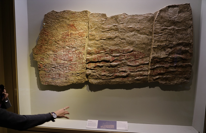
Image courtesy of Ray Swi-hymn via Wikimedia Commons
Çatalhöyük and the First Attempt
One of the earliest candidates comes from Çatalhöyük, a Neolithic settlement in present-day Turkey. A wall painting dated to around 6200 BCE shows a dense cluster of rectangular shapes beneath what some researchers interpret as a twin-peaked volcano, likely Hasan Dağ.
If this reading is correct, the image may represent a settlement plan seen alongside a landmark. It would be one of the earliest known attempts to translate lived space into a visual structure.
But this interpretation is not universally accepted. Some archaeologists see no map at all, only abstract pattern or symbolic imagery. Without written explanation, certainty is out of reach. What remains important is the possibility itself, that space might already have been drawn rather than only described.
The Babylonian World
The oldest surviving object broadly recognized as a map is the Babylonian Imago Mundi, created around the sixth century BCE.
The clay tablet presents the world as a circular system. Babylon sits at the center. The Euphrates runs through it. Surrounding regions are arranged around the edges, and a circular ocean lies beyond everything.
By modern standards, it is not accurate, but accuracy was never the point. The tablet organizes geography through structure, bringing spatial, mythological, and political ideas into a single diagram. In this sense, the Imago Mundi feels closer to a visual system than a document. It turns the world into something structured, readable, and contained.
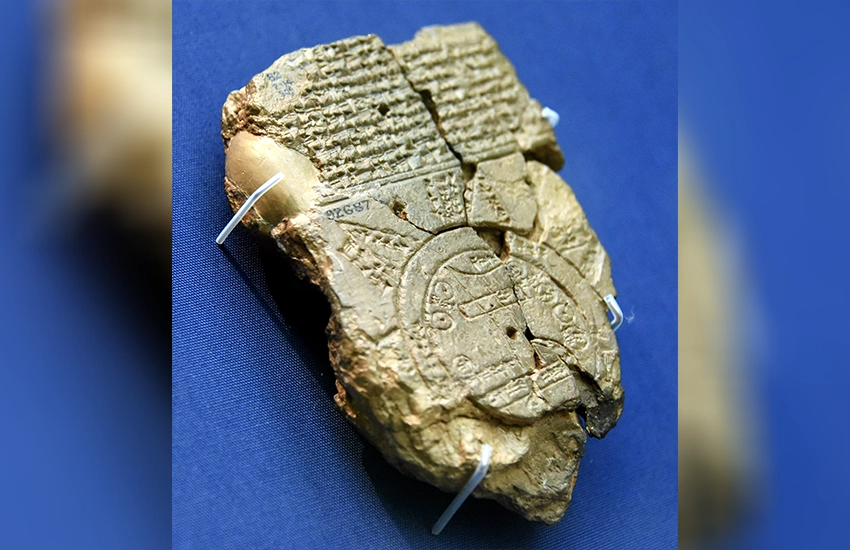
Image courtesy of The British Museum via Wikimedia Commons
Designing the World
Maps begin with reduction. The world is too large, too detailed, too continuous, so it has to be simplified. That simplification is actively formed by decisions about what to keep, what to remove, what becomes symbol, and what becomes background.
A river becomes a line. A city becomes a dot. A mountain becomes a shape that stands in for elevation. Maps rely on visual conventions that make complexity readable. From this angle, early maps solve a design problem that still exists today. how do you turn complexity into something that can be read at a glance?
Graphic design follows the same logic. Hierarchy, abstraction, spacing, symbols, clarity. The language changes, but the underlying problem remains. A map is one of the earliest systems for organizing information visually.
Maps Became Systems
Over time, maps became more precise as measurement, astronomy, and exploration developed. Greek geographers introduced systematic approaches to scale and latitude. Medieval maps mixed observation with theology. In the Renaissance, cartography developed projection systems that made it possible to translate a curved earth into flatter and more consistent representations.
Later, printed atlases standardized geographic knowledge across continents. Today, digital maps update in real time and respond to movement, data, and infrastructure.
So What Was the First Map?
If we describe a map as any early attempt to symbolize real space visually, the Çatalhöyük painting is a candidate, though this is still debated. If we define a map as a clearly recognized and surviving representation of the world, the Babylonian Imago Mundi is the earliest example.
The more interesting question is not which object came first, but what changed when such objects appeared at all. At some point, humans stopped only describing the world and began organizing it visually. That change, from description to construction, points to the beginning of mapping. And seen this way, the first map was one of the earliest moments when space became design.
Short Answers (FAQ)
What is the earliest known map?
There is no single universally agreed earliest map. The Çatalhöyük wall painting (c. 6200 BCE) is often suggested as a candidate, while the Babylonian Imago Mundi is the earliest surviving and clearly identifiable world map.
What is the Babylonian Imago Mundi?
The Babylonian Imago Mundi is one of the earliest surviving world maps, showing a symbolic representation of the world within Babylonian cosmology.
Why are early maps important in history?
Early maps show the shift from describing space in words to organizing it visually, marking the beginning of mapping as a structured form of design and knowledge.